Kannapolis offers a variety of different greenways for walking and biking. The 8th Street Greenway and Bakers Creek Greenway together create a 2-mile loop from Bakers Creek Park, along West A Street, up 8th Street to Loop Road and over to Village Park.
Greenway Maps and Access
To access the existing greenway, parking is available at Bakers Creek Park, Village Park, and the YMCA. Please note, Bakers Creek Park has a gated parking lot and is only open during park hours. Cars left past closing time may be locked in over night. However, both Village Park and the YMCA lots are open lots and can be accessed at any time of day, including early morning.
Parks – Greenway Brochure | | Greenway Vicinity Map
Bakers Creek Greenway
The Baker’s Creek Greenway runs through Baker’s Creek Park and connects the 8th Street Greenway with Baker’s Creek Park and then Village Park.
8th Street Greenway
This 10-foot-wide paved trail and pedestrian walkway connects Loop Road to 8th Street, crosses 8th Street and continues to West A Street. Once the Greenway crosses West A Street, it ties into the existing Bakers Creek Park Greenway. The 8th Street Greenway was partially funded through the Department of Transportation’s (NCDOT) transportation enhancement grant under the Transportation Equity Act for the 21st Century (TEA-21).
Irish Buffalo Creek Greenway

(Click on image to view enlarged map)
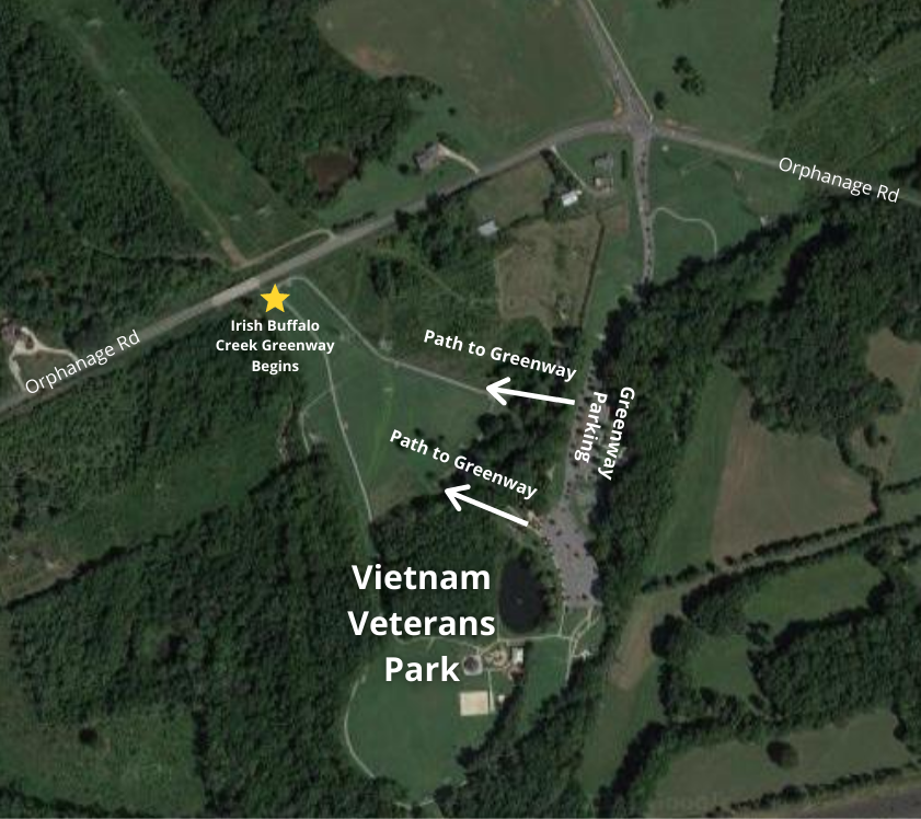
The first phase of the greenway is 2.7 miles and runs along a creek from Orphanage Road to Rogers Lake Road, connecting Bakers Creek Park, Safrit Park and Vietnam Veterans Park. The greenway is ten feet wide and paved and features three pedestrian bridges. The steel and wood bridges are installed along the portions of the greenway which cross portions of the creek.
Vehicle parking for access to the greenway will only be available at Vietnam Veterans Park. Pedestrians can access the greenway at these locations: Oakwood Avenue (across from the Lantern Green and Stonewyck neighborhoods), Vietnam Veterans Park and Rogers Lake Road.
The greenway is part of the Carolina Thread Trail.
Carolina Thread Trail
The City’s Bakers Creek greenway and future greenway plans are part of the Carolina Thread Trail, which is a regional plan for a network of greenways and trails across 15 counties and reaching 2.3 million citizens.
Pedestrian and Bicycle Plan
The Kannapolis Walkable Community Plan was initiated by the City of Kannapolis and made possible through a $24,000 North Carolina Department of Transportation Grant. The goals of the Plan are to create a more livable community through the promotion and development of pedestrian amenities and facilities which are safe, accessible, and connect destinations within the City (and larger region) through alternative transportation and circulation networks. Click the link to view the Walkable Community Plan or the Kannapolis Bicycle Plan.